Showing posts with label laurentide ice sheet. Show all posts

Saturday, May 25, 2013

The Retreat of the Laurentide

Hello everyone! 
Previously I’ve told you a bit about the formation of the Laurentide ice sheet, the ice sheet that covered a large part of North America in the last ice age. However, since there obviously isn't a glacier there now, the great Laurentide has long since retreated. The ice sheet began to retreat around 20,000 years ago. By 18,000 years ago, it was gone from the region between Cape Cod to the Maine coast. Then, by 15,000 years ago, it has retreated from all of southern New England and the Gulf of Maine. 9,000 years ago all that was left of the Laurentide was an area in Quebec and Labrador with a size similar to Greenland.

How the Laurentide shrank over time as the climate warmed.

Something that I have found interesting is how scientists have managed to calculate the rate of retreat of this glacier. Afterall, it was long gone by the time we ever got around to studying it. Basically, geologist have used radiocarbon and surface exposure dating techniques to determine the time at which the glacier left that area. Then they found the distance that location was from the starting point. By using the distance and age, they could figure out the speed by simple using distance divided by time (Ullman).

West Quebec: 700-900 meters/year
Central Quebec: 300 meters/year
East Quebec: 150 meters/year

From this data it is clear that the ice sheet did not move at a constant rate. It moved at a much faster rate in the west and was significantly slower in the east. This could be because in order for the glacier to advance and grow if would need more snowfall to counterbalance the melting due to the warmer climate. On the east, the Atlantic Ocean provided enough moisture to supply the glacier with adequate snowfall to slow the rate of ablation. On the west, there were no water sourced, so the glacier did not receive as much snow to slow the melting.
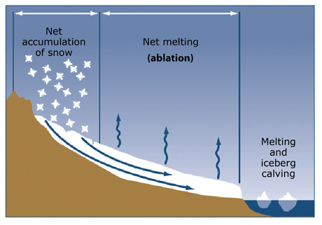
A glacier grows if the accumulation is greater than the ablation. The Laurentide shrank because the ablation was greater than the accumulation.

It is important for there to be data about the rate of ablation of the Laurentide ice sheet for two reasons. First, it helps us get a better understanding of earth’s past and history. Second, it also gives us an idea about what might happen to the Greenland Ice Sheet and the Antarctic Ice Sheet if the climate continues to warm.


Here is a link to a great animation of the Laurentide's retreat.

Have a fantastic day!


Image/Animation Citations:


Laurentide Ice Sheet. CSDMS. University of Colorado, n.d. Web. 25 May 2013. <http://csdms.colorado.edu/wiki/Movie:Laurentide_Ice_Sheet>.


Short, N. Laurentide Ice Sheet at circa 14,000 B. Digital image. Recovering the Lost World, A Saturnian Cosmology -- Jno Cook Chapter 9: Event of the Younger Dryas. N.p., 25 Mar. 2013. Web. 25 May 2013. <http://saturniancosmology.org/bin/lauren14kbp.jpg>.


The accumulation and ablation of a glacier. Digital image.
USGS. U.S. Department of the Interior, 9 Jan. 2013. Web. 25 May 2013. <http://pubs.usgs.gov/fs/2009/3046/images/fs20093046_fig03.png>.


All About The Laurentide

Hello everyone!
Today we are going to talk a little bit about the geologic history of Massachusetts and New England. As you probably know, in Earth’s past, the planet has experienced periods of cooling called ice ages for the past 2.6 million years during the Quaternary period. In these ice ages, large, moving ice masses, called glaciers were a prevalent feature of the topography. Even today, there are glaciers left over from our last ice age, although they are much less common.

This is just an example of the types of glaciers that were common during the last ice age.

The most recent ice age peaked about 23,000 years ago. Glaciers covered approximately 1/3 of all land on earth. All of these glaciers were formed by snow that turned into ice through compaction and  recrystallization. Because of all the snow used to created these giant ice masses, nearly 5% of the earth’s water was trapped in the glaciers, which is over 10 million cubic miles of water. This caused the sea levels to fall eustatically, so the coasts then extended 100 miles farther out to sea than they do today. During the ice ages, the earth was a different planet.


This is an image of what the coastlines of the world would have looked like during the last ice age.

In North America, an ice sheet covered a large portion of the continent. It was called the Laurentide Ice Sheet and it stretched from northern Canada to Long Island, a total of more than 5 million square miles. The reason that this ice sheet was able to become so large was because at that time there was a positive glacial budget. More snow was being added than was melting, so the glacier was able to advance. Since it was an ice sheet, it did not carve out the land the way an alpine glacier would, instead, it blanketed the land as it spread out from its center. This spreading was caused by the intense weight and pressure that the ice was subjected to as more snow and ice was added above it. Although a continental ice sheet like the Laurentide does not form erosional features such as cirques and aretes, it does leave behind depositional features when it retreats. Many of these features are still visible today in the Massachusetts area, and they serve as a constant reminder of our impressive geologic past.


This is the location of the Laurentide ice sheet as well as the other, smaller ice sheets that covered North America at this time.

In the next few weeks, I plan on visiting some of these depositional features near me, but in the meantime I’ll continue to fill you in about the history and features of the Laurentide ice sheet and the Massachusetts area.


Have a fantastic day!


Image Citations:

Lougheed, Stephen C., and Natalie Morrill. The location of the Laurentide Ice Sheet. Digital image. Opinicon Natural History. Queen's University, n.d. Web. 25 May 2013. <http://opinicon.files.wordpress.com/2012/04/laurentide-ice-sheet.jpg>.


National Geophysical Data Center. Sea Levels in the Last Ice Age. Digital image. Not by Fire but by Ice THE NEXT ICE AGE - NOW! N.p., 11 July 2011. Web. 25 May 2013. <http://www.iceagenow.com/SeaLevel_LastIceAge.gif>.

Nygren, Harley D. Antarctica. Digital image. Phys.org. Phys.org, 1 May 2013. Web. 25 May 2013. <http://cdn.physorg.com/newman/gfx/news/hires/2013/howtheiceage.jpg>.