Showing posts with label feature fact file. Show all posts

Tuesday, May 28, 2013

River Features


Feature Fact File: River features


There are many features on a river, but here is a brief description of a few of them:

Meanders - The bends in the river. They form when the water in a river encounters more friction on one side of the channel than the other, so the water on each side moves at different speeds. The faster water has more energy so it erodes more, while the slower moving side had less energy and deposits more. Therefore over time, the river curves towards the side where the erosion is occurring, forming meanders.


Meander Cutoffs - A shortcut for the river across the riverbed. The river decided that it doesn’t want to go around the entire meander, so it cuts across the river bank.

Oxbow Lakes - Abandoned meanders. When the meander cutoff becomes the preferred way to travel, deposition from the meander cutoff can separate the meander from the rest of the river, creating an oxbow lake.


Point Bar - The inside of a meander where a mini sandbar is formed from all the deposition. The water encounters more friction on this side so it slows down, losing energy. It no longer has enough energy to carry the sediment, so it is deposited here, forming a point bar.

Cutbanks - The outside of a meander where there is a lot of erosion. The river moves faster here since there is less friction. Therefore the water has more energy and can carry a lot of sediment, so it erodes a lot.


Floodplains -The area around the river made of fine grained material that would be underwater in a flooding event.

Levees - Sandy ridges running parallel to the river. When a river floods, the largest material is deposited first on the edge of the river, forming the levees.


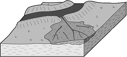
Crevasse Splay - A place where water has broken through a river and splays out onto the floodplain.


Yazoo Streams - Smaller streams running parallel to the river. They form after a flooding event when the water reorganizes itself into a this smaller stream. Yazoo streams indicate that the floodplain is very large.

Meander Scars - Marks on the river bank where meanders once were but have since moved. There is usually deposited material there.


Have a fantastic day!


Image Citations:


Crevasse Splay. Digital image. GeoDZ.com. N.p., n.d. Web. 27 May 2013. <http://www.geodz.com/deu/d/images/1674_crevasse_splay.png>.

Diagram of erosion and deposition on a river. Digital image. Peru. N.p., 3 May 2011. Web. 27 May 2013. <https://blogger.googleusercontent.com/img/b/R29vZ2xl/AVvXsEhrd3zYWdlF8vZdRVVoAn2Edvirtxi0lriCnDFoJ832G-lQ965FWPR6wwXTAepPCkq1YD0o3hrlTd0NnQNVmCRtvMJL3SyshVoOm5DxIuuvaChfCk16jEGRavW3hHLvoOYr1qNV2kaRlmW1/s1600/PointBarCutBank.jpg>.

Diagram of the formation of an oxbow lake. Digital image. Rashid's Blog. N.p., 27 Apr. 2011. Web. 27 May 2013. <http://cgz.e2bn.net/e2bn/leas/c99/schools/cgz/accounts/staff/rchambers/GeoBytes%20GCSE%20Blog%20Resources/Images/Rivers/ox-bow_lake.gif>.

Floodplain and Levees. Digital image. Floodplains. N.p., n.d. Web. 27 May 2013. <http://www.angelfire.com/hero/gerald_koh_s9029362a/images/floodp14.jpg>.

Lemke, K. A. River features. Digital image. Glogster. N.p., n.d. Web. 27 May 2013. <http://c3e308.medialib.glogster.com/media/d5/d56c1133c70dddbee9cadaec284485495a1c640683dbd4920338ea1011dd8cf2/floodplain1-gif.gif>.

Wechsler, Doug. Meanders. Digital image. Salt Marsh Life. N.p., n.d. Web. 27 May 2013. <http://saltmarshlife.com/image/Saltmarsh%20meanders%202903-66.jpg>

Kettle Holes

A kettle hole in Iceland

Feature Fact File: Kettle holes and lakes

What are kettle holes?
    Kettle holes are depression in the ground that have very steep sides. They can fill up with water to form lakes or ponds.

How do kettles form?
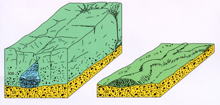
    Kettle holes form when a chunk of ice that is separated from the glacier is buried by sand. They are very large pieces of ice, so they form a depression where they sit. Eventually, the ice melts, leaving behind a hole.


How a kettle hole forms.


Where do kettles form?
    Kettles form in the outwash plain of a glacier.

Have a fantastic day!


Image Citations:

Ingólfsson, Ólafur. Kettle Hole in sandur sediments, in front of the 1890 Brúarjökull surge moraine. Digital image. Ólafur Ingólfsson. N.p., 2004. Web. 26 May 2013. <https://notendur.hi.is/oi/Eyjabakkajokull%20photos/Kettle%20hole.JPG>.

Kettle Hole Formation. Digital image. Cairngorm Landscapes. N.p., n.d. Web. 26 May 2013. <http://www.landforms.eu/cairngorms/images/kettle-hole.gif>.

Drumlins

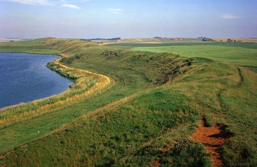
A drumlin.

Feature Fact File: Drumlins

What is a drumlin?
Drumlins are asymmetrical hills made of poorly sorted till. They typically have one very steep side and one more gradually sloping side which indicates the direction the glacier moved. They are typically found in groups.

How does a drumlin form?  
A drumlin forms when the glacier bulldozes a pile of sediment (till) forward as it advances. This is what forms the steep side of the drumlin. Eventually, the glacier continues to move forward, but instead of continuing the bulldozing motion, the glacier slides down the other side of the pile, forming the less steep side of the drumlin. However, this is not the only way in which a drumlin’s gradual side is formed. It can also be created if the glacier stops moving after it bulldozes the material, and instead, meltwater runs down the snout, smoothing the other side of the drumlin.


A nice example of the formation of a drumlin.
   
Where do drumlins form?
    Drumlins form at the snouts of glaciers, where the sediment is being pushed forward.

Other interesting facts:
    The word drumlin comes from the Gaelic word drum, meaning “little ridge”. This feature was first named by Maxwell Henry Close, an Irish geologist and clergyman, who studied the glaciers in Ireland in the 1800s.

Have a fantastic day!


Image Citations:

Drumlin Formation. Digital image. East Lothian Landscapes. N.p., n.d. Web. 26 May 2013. <http://www.landforms.eu/Lothian/images/drumlin.jpg>.


Morley Bow Valley, Alberta. Digital image. Vincent Massey Junior High School. N.p., Feb. 2002. Web. 26 May 2013. <http://dnowlan.ca/VM/science7/planetearth/drumlin.jpg>.

Eskers


An esker

Feature Fact File: Eskers

What exactly is an esker?
    An esker is a narrow ridge of stratified sediment, meaning that it is well sorted and has layers. The reason it is well sorted is due to the fact that the sediment used to be carried in a stream of meltwater. Eskers have steep sides and can be up to 500 miles (but not continuous) long. They are not usually more than 1000 feet wide and 150 feet tall.

How do eskers form?
    Eskers form when streams of glacial meltwater form tunnels underneath the glacier. These streams transport sediment that the meltwater picks up down is tunnel. Over time, this sediment is deposited in the streambed and eventually the tunnel will be completely filled. When the glacier retreats, the sediment remains in the ridge-like shape of the ice tunnel that it once filled.


As shown here, eskers form when ice tunnels get clogged with sediment, leaving a ridge behind when the glacier retreats.

Where do eskers form?
    Well, we kind of just talked about how they eskers form in these ice tunnels. The tunnels themselves are typically located in the ground moraine of a continental glacier.

Other interesting facts:
    Due to their long winding shape, many roads are built on top of eskers.

Have a fantastic day!


Image Citations:


An esker. Digital image. NE Geology Kids. OneGeology, n.d. Web. 25 May 2013. <http://www.onegeology.org/extra/kids/images/P219697esker.jpg>.


Formation of an esker. Digital image. North Dakota. North Dakota Geological Survey, 29 Aug. 2007. Web. 25 May 2013. <https://www.dmr.nd.gov/ndgs/ndnotes/Eskers/images/esker%20formed%20copy.jpg>.

Kame Deltas

Feature Fact File: Kame Deltas
   
What is a kame delta?
Kame deltas are irregularly shaped hills of well sorted and stratified sediment. They are a type of kame, but they form in a distinct manner (which we will discuss in a few moments). Because of their unique formation, one of their sides are much steeper than the other, which is called an ice contact slope. Kame deltas are layered are layered because streams deposited the sediment. The layers are always parallel to the less steep side.

How do kame deltas form?
    Kame deltas form when a stream of meltwater carrying sediment flow off the snout of the glacier. This causes the sediment to build up at the base, making the snout of the glacier seem less steep. When the glacier retreats, the kame delta remains with two distinct sides: one that was touching the glacier (the ice contact slope), and the one that the melt water flowed over.


If you look to the right of the image, you can see how a kame delta forms.


Where do kame deltas form?
    Kame deltas form at the snouts of glaciers.

Fun fact:
Kame deltas are also sometimes called ice contact heads.


Image Citation:

Development of Kames. Digital image. Access Science. McGraw Hill Education, n.d. Web. 26 May 2013. <http://www.accessscience.com/loadBinary.aspx?filename=290200FG0040.gif>.

Kames

A kame

Feature Fact File: Kames

What is a kame?
    A kame is a mound of well sorted sediment, usually sand or gravel. The sediment may be somewhat layered. They form in a variety of sizes and shapes, however, most are vaguely cone-shaped and are not very tall.

How do kames form?
    Kames form when melt water and the sediment it carries collect in a depression on the top of the glacier. Slowly, as the glacier melts, the collection of sediment is lowered to the ground where it forms a hill.


The formation of a kame (and some other features)


Where do kames form?
    Kames form near the snout of the glacier, where most of the ice is melting.

Fun Facts:
    The word kame is from the scottish word for “crooked and winding”.
    If lots of kames form in the same area, it is called a kame field.

Have a fantastic day!


Image Citations:

Kame. Digital image. Stories in Stone Travels in Time. N.p., n.d. Web. 26 May 2013. <http://www.uleth.ca/edu/currlab/handouts/geology/ice52kamekettlebig.jpg>.

The formation of a kame and other glacial features. Digital image. N.p., n.d. Web. 26 May 2013. <http://www.york.ca/NR/rdonlyres/rc4kh3lhixia4pqjohahgeauigckxjlekrveimghsb77tr4qo4ynaw5tfsd7ao562nzxz2yk3esbsf63rnmr46wg5h/Kame.gif>.

Glacial Lakes

An artist's rendition of a glacial lake.

When the Laurentide Ice Sheet retreated about 18,000 years ago, features called glacial lakes were formed. They were fed a constant supply of meltwater by the nearby glacier and these streams deposited sand and gravel into the lakes. In this region, two particularly prominent lakes were Lake Sudbury and Lake Concord.

Lake Sudbury formed first, and it was located just south of present day Massachusetts Rt. 2. It was about 4 miles wide and 20 miles long. It was around 90 feet deep. Later, as the glacier retreated more, Lake Concord was created north of Rt. 2. On its northern side it was contained by ice and on the south and west it was contained by higher ground.

A map showing the general coastlines of Lake Sudbury and Concord.


It is thought that there were also many chunks of ice in these lakes that had yet to melt, making it likely that instead of being one huge expanse of water, they were actually made of many smaller lakes. This possibility also makes it unlikely that there were many waves on the lakes and therefore less erosion would have occurred. Scientists have searched for evidence of erosion from waves, but they have been unsuccessful, which adds proof to the idea that these lakes were choked with pieces of the glacier.

Eventually, since these lakes are no longer present, all the water drained away through the various streams and rivers that formed during this time. This left behind a lake basin filled with clay and silt. In fact, colonial settlers in Massachusetts used this clay to make bricks to build their houses with. They also left behind features such as kame deltas, which you can learn about here.

Have a fantastic day!


Image Sources:

"Map of Concord, Mass." Map. Geological Survey Professional Paper. Vol. 475. Washington: United States Government Printing Office, 1963. 143. Google EBook. Google. Web. 28 May 2013. <http://books.google.com/books?

id=LOAqAQAAIAAJ&printsec=frontcover&source=gbs_ge_summary_r&cad=0#v=onepage&q=colonial&f=false>.
Pickering, Byron. Glacial Lake Missoula. Digital image. ENB 105. N.p., n.d. Web. 28 May 2013. <http://1.bp.blogspot.com/-
cdOC2Uv1DqQ/T2Kp5i5KMKI/AAAAAAAAAEQ/1P01F7sLHPs/s1600/Glacial%2BLake.jpg>.