Showing posts with label eskers. Show all posts

Tuesday, May 28, 2013

Acton Arboretum

Map of the Acton Arboretum. The esker is located on the southwestern tip of the Blog Loop.


Hello everybody!

Today I went to the Acton Arboretum, home of a special glacial feature: an esker! If you would like to learn more about how an esker forms, please check out this post.


Looking up to the top of the esker.

This esker is located on the southern tip of the Bog Loop Trail, one of the many paths in the arboretum. It was about 20 feet high and it runs north-south, which indicates that the glacier moved in that direction as well, since eskers typically run parallel to the direction of glacial flow.
The esker was made of well sorted sediment, which makes sense since all of the sediment would have been deposited by water. In fact, the stream that deposited all of the sediment to create this esker was one of the tributaries that fed glacial lake Sudbury many years ago.


The view down one side of the esker.


The view down the other side of the esker.

Another thing I noticed while I was walking through the Arboretum was how many stone walls there were throughout the woods. During colonial times, farmers would remove the stones used to make these walls out of the ground that they were plowing. One of the reasons that stone walls are so abundant in this area is because the soil is glacial till, sediment that was shoved along and eroded under the glacier. Glacial till is poorly sorted, so having large rocks in it is very common. Unfortunately, it does not lead to easy farming...

The Acton Arboretum is also renowned for its flowers, and when I visited, many were in full bloom.


Have a fantastic day!

Image citations:
Arboretum Map. Digital image. Acton Conservation Land. N.p., n.d. Web. 26 May 2013. <http://www.actontrails.org/images/mArboretum.jpg>.

Eskers


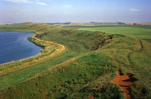
An esker

Feature Fact File: Eskers

What exactly is an esker?
    An esker is a narrow ridge of stratified sediment, meaning that it is well sorted and has layers. The reason it is well sorted is due to the fact that the sediment used to be carried in a stream of meltwater. Eskers have steep sides and can be up to 500 miles (but not continuous) long. They are not usually more than 1000 feet wide and 150 feet tall.

How do eskers form?
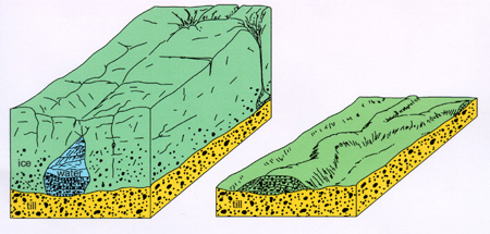
    Eskers form when streams of glacial meltwater form tunnels underneath the glacier. These streams transport sediment that the meltwater picks up down is tunnel. Over time, this sediment is deposited in the streambed and eventually the tunnel will be completely filled. When the glacier retreats, the sediment remains in the ridge-like shape of the ice tunnel that it once filled.


As shown here, eskers form when ice tunnels get clogged with sediment, leaving a ridge behind when the glacier retreats.

Where do eskers form?
    Well, we kind of just talked about how they eskers form in these ice tunnels. The tunnels themselves are typically located in the ground moraine of a continental glacier.

Other interesting facts:
    Due to their long winding shape, many roads are built on top of eskers.

Have a fantastic day!


Image Citations:


An esker. Digital image. NE Geology Kids. OneGeology, n.d. Web. 25 May 2013. <http://www.onegeology.org/extra/kids/images/P219697esker.jpg>.


Formation of an esker. Digital image. North Dakota. North Dakota Geological Survey, 29 Aug. 2007. Web. 25 May 2013. <https://www.dmr.nd.gov/ndgs/ndnotes/Eskers/images/esker%20formed%20copy.jpg>.